

Gibb River Road 4WD Safety Guide (2026 Update)

The Gibb River Road in the Kimberley region of Western Australia is an adventure, not a Sunday drive. It’s remote and rough in places, but very manageable when you understand the realities of the road. The Road Reality Snapshot (2025 update) shows you exactly what to expect — before you even turn a wheel. This 4WD safety guide then breaks down the practical, real-world details based on lived experience.
➡️ See the full Gibb River Road guide here.
I’ve driven the Gibb solo in my Toyota Land Cruiser Prado, and these are the questions people ask the most:
- Do I really need a 4×4?
- Is the Gibb still as rough as everyone says?
- What does the Gibb River Road Really Look Like Today?
- What tyres and pressures should I use?
- How do I handle corrugations and water crossings?
- How much fuel and water do I need?
- What’s safe if I’m travelling alone?
But with the right preparation, equipment, and mindset, thousands of people drive it safely every dry season.
Think of the Gibb as remote and unforgiving, not reckless and wild. Your decisions influence your safety more than the road itself. If you:
- Slow down
- Respect road conditions
- Prepare your vehicle
- Carry proper communications
…you significantly reduce your risk.

Solo travellers can absolutely do the Gibb. I have. More than once. You just need to treat planning as part of the trip — not something you skim over the week before.
Road Reality Snapshot (2025 update)
ROAD REALITY SNAPSHOT (2025 UPDATE)
I drove the Gibb in August-September 2025 again, and my honest impression is that the Gibb River Road isn’t the wild, unpredictable track it once was. Large sections — especially on the western side — are now sealed or freshly upgraded. Many creek crossings have concrete bases, steep hill climbs are bituminised, and the first stretch from both ends is far smoother than travellers expect.
Recent upgrades have transformed the eastern half, too. Corners have been widened, floodways reinforced, and bitumen extends past both the Derby and Kununurra turn-offs.
What this means for you:
1. The Gibb is not a goat track.
2. It is well signposted and easy to navigate.
3. You will drive more bitumen than you expect, especially early on the track.
4. The real challenges come from corrugations, side tracks,
vehicle setup, and driver behaviour, not the main road itself.
The Gibb still requires preparation — but it’s no longer the extreme, remote slog it was 20 years ago.
Do You Need a 4WD for the Gibb River Road?

Short answer: yes.
The Gibb is a long, with a lot of unsealed road sections with:
- Corrugations
- Washouts and ruts
- Creek and river crossings
- Rocky sections
- Soft sand in places
A 4WD gives you:
- Higher ground clearance
- Stronger suspension
- Low-range gearing
- Better underbody protection (bash plates)
- The ability to fit suitable all-terrain tyres
A 4WD gives you clearance, stability, traction, and the ability to fit the correct tyres. An AWD might get through in an ideal year, but it’s not designed for the conditions.
It’s getting through the side tracks to places like Adcock Gorge, Bells Gorge, Mitchell Falls and Mount Hart Station that a 4WD comes into its own.
I went through July – August 2023, and there was a huge weather event, and the rivers were raging. Last year 2025, they were bone dry, including the Pentecost, Barnett River Crossing and Durack. I still think a 2WD or AWD are not ideal.
Is the Gibb River Road Dangerous?
It can be — but the danger level depends on your preparation and behaviour, not the road itself.
The biggest risks are:
- Excessive speed on corrugations
- Low tyre pressures
- Overloaded vehicles
- Water crossings after rain
- Wildlife at dawn/dusk
- Heat and dehydration
- Lack of communication equipment
- Inexperience with Outback driving
The Gibb is not a highway. Respect it, prepare well, and drive to the conditions — you’ll be fine.
Solo travellers can absolutely do it. I have. Below, you get a heads-up on what it’s really like.
What the Gibb River Road Really Looks Like Today
Most travellers are surprised by the actual road conditions. For most of its length, the Gibb is a wide, formed gravel road. It is not a narrow bush track. It is also not the “wild Outback ordeal” many older articles describe.
Here’s what to expect today:
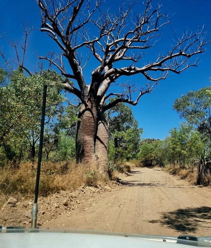
1. The western side has long stretches of bitumen
The Derby end is heavily upgraded. Hills, steep climbs, and approaches are sealed, and the bitumen now extends far further than it used to. Creek crossings on this side often have concrete bases, making them straightforward in the dry season.
2. The eastern side has seen major upgrades, too
The Kununurra end has changed a lot in recent years. Corners have been widened, floodways rebuilt, and many creek crossings have concrete or reinforced bases.
You’ll also hit bitumen much earlier than expected, and the sealed sections now stretch well beyond the main highway turn-off toward El Questro.
3. The road is extremely well signposted
You won’t get lost. Every major turn, gorge, station, and access track is clearly marked. Navigation is simple — the challenge lies in conditions, not directions.
4. Corrugations are the real issue, not technical difficulty
Corrugations build up as the season progresses. They’re not “hard” to drive — they’re uncomfortable. Slow down, drop tyre pressures, and your vehicle will handle them fine. Rushing, towing too fast, or ignoring tyre pressures is what causes most damage, not the corrugations themselves.
Key Takeaway
The Gibb River Road is no longer an untouched, remote 4WD gauntlet.
It’s a mix of bitumen, good gravel, and some rougher patches — with corrugations being the main discomfort.
Prepared travellers, with the right tyres and driving approach, find it very manageable.
Essential Vehicle Requirements for the Gibb River Road
You don’t need the most kitted-out 4WD on the track — but you do need these basics.
Tyres: All-Terrain is Non-Negotiable
Bald, highway, or road tyres do not belong on the Gibb.
Choose:
- All-Terrain (A/T)
- Light Truck construction (LT)
- Minimum 2–3 ply sidewall
Carry:
- 1 full-size spare (2 recommended)
- Tyre plug kit
- Compressor
Suspension & Clearance
Stock 4WD suspension can handle the Gibb River Road, but older or softer setups can struggle under load or over long corrugated sections.
Many travellers consider getting a small lift to improve clearance and ride quality. A lift isn’t essential, but it can help with:
- Clearance over dips and washouts
- Ride comfort on corrugations
- Overall control on rougher sections
My Prado has good factory clearance and solid suspension, so I haven’t felt the need for a lift. The key is making sure your existing suspension is in good condition — no leaking shocks, sagging springs, or worn bushes. A well-maintained standard setup is often more than enough.
Recovery Points
Factory tie-down points are not recovery points. They’re designed for transporting the vehicle, not for pulling it out of trouble.
If your vehicle is like mine, you may have only one factory-rated point. My Prado came with a rated tow point at the rear, but the front point is just a tie-down — not safe for recoveries. That means a proper aftermarket front recovery point need to be installed.
For the Gibb River Road, you should have:
- One rated point at the rear
- One rated point at the front
This gives you safe options, no matter which direction assistance comes from. Get to know your car. Read the manual.
Underbody Protection (commonly known as ‘bash plates’)
Highly recommended for:
- Fuel tank
- Radiator
- Transmission
Weight & Payload
Overloading is the cause of most breakdowns.
Know your:
- GVM
- GCM
- Rear axle load
- Towing capacity
Stay within limits.
Water Crossings: What You Must Know

Most water crossings on the Gibb are shallow in the dry season — but after rain, everything changes.
Depth
If you can’t walk it, don’t drive it.
Walking the crossing lets you check depth, the base, the flow and any holes or rocks hidden under the surface. Generally, if I am unsure, I just wait for the next car. Honestly, you won’t be waiting long, and if you are, grab a cuppa. You may encounter someone coming from the other side, which is even better.
A snorkel only protects your engine from water ingestion — it will not protect you from fast-moving water. Rapid flow can shift a vehicle sideways with surprising force, even at shallow depths.

I’ve waited at the Durack and the King Edward River crossings before until another driver arrived so we could assess it together.
Solo doesn’t mean doing everything alone — it means choosing the safest option every time.
Entry & Exit
Put your car in Low 4
Go slow.
Avoid bow waves.
Be aware of your vehicle’s air intake location if you do not have a snorkel, and understand the maximum water depth your vehicle can safely cross.
A snorkel:
- Helps protect your engine from water
- Helps reduce dust intake
But it doesn’t make a bad crossing safe. If it looks risky, don’t attempt it.
Flow Speed
If the water is pushing against your legs — don’t attempt it.
When to Turn Around
If your gut says no — turn around.
The Gibb is not worth drowning a 4WD or yourself.
Corrugations, Tyre Pressures & Road Conditions

Corrugations build up as the dry season progresses. They aren’t dangerous in themselves, but they do demand the right technique. The key is slowing down, lowering your tyre pressures, and letting the vehicle settle into the surface. Most damage on the Gibb comes from rushing, towing too fast, or running tyres too hard — not from the corrugations themselves.
If you’re new to driving on outback roads, a 4WD training course is one of the best things you can do before attempting the Gibb. These courses teach you how to handle corrugations, water crossings, tyre pressures, and recovery — all in a controlled environment. They’re practical, confidence-building, and far more useful than learning the hard way on a remote track.
What Corrugations Are Really Like
Deep, harsh, relentless.
They loosen bolts, destroy tyres, and shake everything.
Safe Tyre Pressures
A big part of Gibb River Road 4WD safety is tyre choice and air pressures.
- Cold pressures: 30–34 psi on corrugation. Now this will be lower for sand and different again for mud. One size does not fit all when it comes to tyre pressure.
Drop pressures on:
- Corrugations
- Gravel
- Washouts
Reinflate when back on bitumen.
Speed
Slower is safer. I generally drive around 70-80 km/h on corrugated roads, but you have to gauge it for yourself.
High speed on corrugations = catastrophic damage + you can slide, especially around corners. It’s like ice skating when you go too fast around a bend with deep corrugations, you will slide.
Protecting Your Vehicle
- Check bolts daily
- Inspect tyre sidewalls morning/evening
- Secure everything inside the car
- Check everything on the roof to ensure it’s still secure
- Check the bash plates
Fuel, Water & Distance Planning

The Gibb is long, and fuel stops are distant in places. Don’t get caught up in the fact that the Gibb River Road is 660km. The road might be, but several of the attractions are off the road. You will be driving a lot further than this.
I usually fill up in Derby if I’m starting from the west, or in Kununurra when I’m entering from the east. I carry two jerry cans and have a long-range tank, so I’m well covered for the Gibb. Even so, I still top up at Barnett Station and Drysdale River Station when I’m heading up the Kalumburu Road.
Fuel is expensive at the stations, but don’t skip them thinking you’ll fill up at the next stop — they can and do run out in peak season. On the Gibb, availability matters more than price.
Fuel
Know your range under load.
You will use more than normal.
Carry:
- 1 jerry can for safety (2 if towing)
Water
Minimum:
- 10L per person per day
You will need more if hiking. Remember that the water is for washing dishes and everything else if you are freedom camping.
Food
Carry 2–3 days of emergency food.
Essential Recovery Gear Checklist
Must-haves:
- Tyre compressor
- Puncture repair kit
- Recovery boards
- Snatch strap + shackles
- UHF radio
- First aid kit
- PLB or a SAT emergency device
- Shovel
- Work gloves
- Jump starter
- Basic tools
Don’t waste money on:
- Hi-lift jacks
- Winches, unless you know how to use one
Communications: UHF, Starlink & PLBs
Phone reception is patchy on the Gibb. Don’t rely on it.
UHF Radio
A UHF is still one of the most useful tools on remote roads.
You can:
- Call ahead to road trains
- Let oncoming traffic know your position
- Ask for help if someone nearby is listening
Channel 40 is commonly used for road traffic. The main Australian UHF emergency channels are Channel 5 and Channel 35, which should only be used in a genuine emergency.
Starlink or Other Satellite Internet
If you’re running Starlink, you’ll have far more regular access to internet and calls. It’s a big investment but a game-changer for longer Outback travel, especially if you’re working on the road.
Personal Locator Beacon (PLB) or Satellite Device
A PLB or satellite messenger is a simple, relatively low-cost way to summon help in a life-threatening emergency. I personally use a Garmin InReach mini.
For solo or remote travel, I consider it essential.
Wildlife, Heat & Real Outback Hazards
Wildlife
Avoid driving at dawn/dusk — roos, cattle, donkeys.
There are also dingoes around. While I was at Mt Hart station, a dingo was hanging around the campsite. Just don’t leave food out, and keep an eye out if you have children. Dingoes also like shoes that are left out overnight.
DON’T FEED THE WILDLIFE
Heat
- Temperatures in the Kimberley can be extreme.
- Don’t start long walks in the middle of the day if you can avoid it
- Drink regularly, not just when you’re thirsty
- Wear a hat and sun protection
Dehydration
Symptoms hit fast.
Drink before you feel thirsty.
Fatigue
Stop every 1–2 hours. There is something to see every 1-2 hours anyway, so it’s not a drama.
Swap drivers if you can.
Border Crossings in Remote Australia

If you’re combining the Gibb River Road with NT travel, you’ll cross the NT/WA border at some point. Quarantine rules apply everywhere.
Here’s what you need to know:
WA/NT Edge
If you enter Western Australia via Timber Creek way, this border is manned and enforced, and you will be stopped.
Officers inspect vehicles for:
- Fruit and vegetables
- Honey
- Plants and soil
- Wooden items and seeds
This is the most controlled of all WA border crossings in the Top End.
Duncan Road (NT → WA through Nicholson Station) — UNMANNED

The Duncan is remote and not manned, but you must:
- Dump fruit, veg and honey in the bins provided
- Comply with WA quarantine regulations
Even though no officers are present, WA’s strict biosecurity rules still apply. It’s your responsibility to follow them — the fines remain the same if you are caught carrying prohibited items deeper inside WA. I have been stopped on a random opportunistic check along this road once.
SA → WA (Nullarbor / Eucla) — Border

If you’re doing a Lap of Australia, this is the major border you will encounter:
- Staffed checkpoint
- Every vehicle is stopped
- Inspection guaranteed
- You must surrender prohibited items
Quick Summary for Travellers
- Kununurra MANNED — you will be stopped.
- Tanami: Unmanned
- Duncan Road: Unmanned — dispose of restricted items yourself.
- Border Town: MANNED — mandatory inspections. (if you are going into WA)
The Border into South Australia is NOT at Border Town. If you are heading from Western Australia into South Australia, the border inspection will be at Ceduna. Use your fresh grocery items along the Nullabor Road and dispose of them closer to Ceduna.
Quarantine laws aren’t designed to catch travellers out — they protect WA’s agriculture and ecosystems.
Always check what you’re carrying before crossing and dispose of items early to avoid waste.
Safety Tips for Solo Travellers

From one solo traveller to another:
- Tell someone your route
- Know your vehicle
- Check in via Starlink or sat device
- Trust your gut
- Don’t camp near closed roads or flooded crossings
- Carry extra water
- Avoid risky detours
- Don’t push distances in the dark
You can absolutely do the Gibb solo. You got this 🙂
❌ Common Mistakes Travellers Make on the Gibb
- Driving too fast
- Wrong tyres
- Not reducing the tyre pressures
- Too much weight
- Not enough water
- No comms
- Ignoring fatigue
- Attempting water crossings, they shouldn’t
- Rushing the trip
These are all avoidable. Take your time and enjoy this iconic Road.
Gibb River Road 4WD Safety FAQs
Is the Gibb River Road suitable for beginners?
Yes — if you prepare well and drive to the conditions.
Can I tow a caravan on the Gibb?
Only with an off-road-rated van and experience. Many sections are rough.
How long do I need to drive the Gibb safely?
5–10 days, depending on stops.
Check out my itineraries.
Is there phone signal?
Very limited, but at several stations on the Gibb you can get phone reception with Telstra or Optus. The rest of the Gibb it’s sketchy.
What are the most important Gibb River Road 4WD safety items?
For Gibb River Road 4WD safety Planning (Obviously!) + Comms + water + suitable tyres.
Want to keep planning?
Next Guides in This Series
Continue planning your trip with the next Gibb River Road guides:
- Fuel, Food & Supplies
- Maps, Checklists & Tools
- Top Gorges & Waterfalls
- Where to Stay
- Plan Your Itinerary