
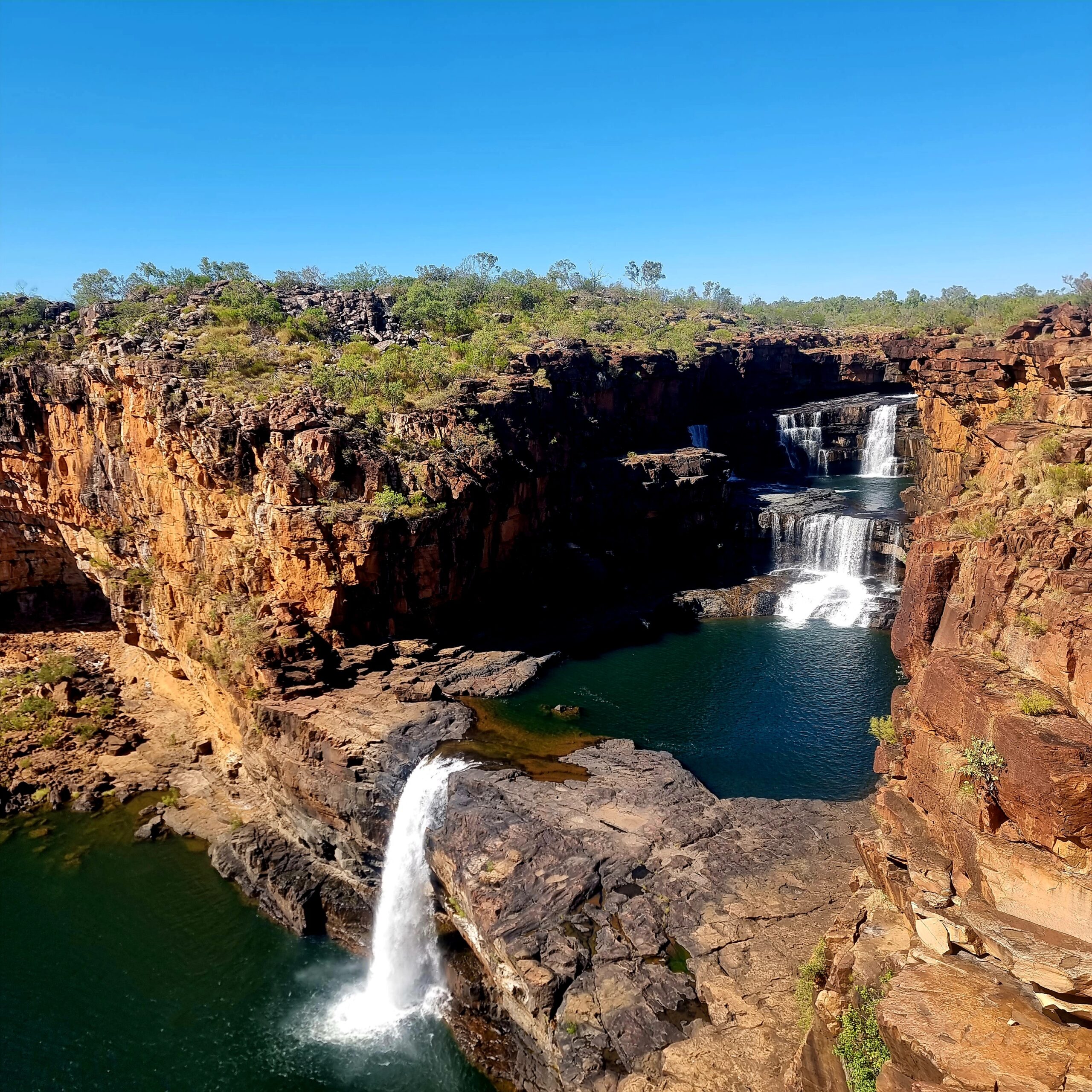
Punamii Uunpuu (Mitchell Falls) is one of the most remote and spectacular places you can visit in the Kimberley. Located on the Mitchell Plateau in far northern Western Australia. Getting here requires commitment, careful planning, and a willingness to travel well beyond sealed roads.
I visited Mitchell Falls as part of my Gibb River Road travels, continuing north via the Kalumburu Road and onto the Mitchell Plateau. It’s not a place you stumble upon — but if you plan it properly, it’s absolutely worth the effort.
➡️ See the full Gibb River Road guide here.
This guide covers how to get to Mitchell Falls, what conditions to expect, permits you’ll need, where to stay, and what the hike is really like, based on my firsthand experience travelling through the Kimberley.

Mitchell Falls at a Glance
Traditional name: Punamii Uunpuu
Location: Mitchell Plateau, northern Kimberley, WA
Access: High-clearance 4WD only via Kalumburu Road
Best time to visit: Dry season (typically May–September)
Permits: Uunguu Visitor Pass required
Hike distance: 8.6 km return
Track difficulty: Moderate to challenging
Alternative access: Scenic helicopter flights available
Fuel & supplies: Limited — plan carefully
Punamii Uunpuu (Mitchell Falls): Why It’s Worth It
If you’ve been travelling the Gibb River Road or tackling the Kimberley by 4WD, you’ve probably heard about Mitchell Falls. It’s remote, spectacular, and one of those places that demands effort and a bit of research.
I’ve been through here as part of my Gibb River Road adventures and can tell you it’s worth making the detour if you plan well.
Getting to Mitchell Falls
There’s no shortcut. Most travellers approach via the Gibb River Road, turning north onto the Kalumburu Road before hitting the Mitchell Plateau Track. This last section is a rough 4WD-only route — think corrugations, creek crossings, and stretches where you’ll be crawling along at 40 km/h.
Update August 2025: Sometimes you just strike it lucky. The Gibb River – Kalumburu Road was graded this trip and was a dream to travel on. In 2023, the road was horrendous, and I met people who turned back because it was too rough.

If you’re doing it yourself, dry season (May to September) is the only safe window. Even then, conditions change fast. Check the Shire of Wyndham–East Kimberley road reports before you leave.
If you’d rather skip the drive (and the corrugations), scenic flights depart from Kununurra, Wyndham, and Drysdale River Station, offering incredible aerial views of the falls and Mitchell Plateau.
King Edward River Crossing

The King Edward River crossing is one of the highlights on the way to Mitchell Falls. I tackled it in July 2023, just after a major weather event in the North, and the river was running high. The Mitchell Plateau doesn’t drain quickly, so water levels can stay up for a while after rain. It’s a crossing that demands respect. You need confidence, especially if you’re driving a high-clearance 4WD on the way to Mitchell Falls or the Mitchell Plateau.
Update August 2025: I went later in the year this time and this is considered more the shoulder season. The King Edward River was very tame. Still cool to cross but more a shallow water crossing.
Permits & Cultural Respect
Mitchell Falls is in the Uunguu country. You’ll need a Uunguu Visitor Pass (UVP), which can be obtained online or at visitor centres along the Gibb River Road. Check out my post on Permits and Passes required on the Gibb River Road, so there are no surprises.
Update August 2025: I bought my pass this year from the lovely Tabitha at Munurra Managers Centre. There are facilities to pay online. You can pay here for the UVP and this also covers you for the stay at Mitchell Plateau. You can also book here for the guided rock art tours

This is a sacred area for the Wunambal Gaambera people, home to some of the oldest rock art in the Kimberley. Take the time to learn about its significance, follow local guidance, and leave no trace.
Where to Stay
The Mitchell Falls Campground is your closest overnight option. Facilities are basic — composting toilets, no showers, and you’ll need to bring your own drinking water.
Many travellers break the trip at Munurru Campground before driving in, or stay at Drysdale River Station if they want more comfort (and a meal they didn’t cook themselves).

If you’re linking Punamii Uunpuu (Mitchell Falls) with other Kimberley stops. Check out my post on Gibb River Road accommodation for more ideas.
Munurru Campground located at the turnoff to Punamii Uunpuu (Mitchell Falls)

Munurru Campground provides a base for exploration and discovery and is close to the Falls if you want to make a day trip.
Munurru (King Edward River) Campground is a peaceful overnight stop on the way to Punamii Uunpuu (Mitchell Falls) and the Ngauwudu (Mitchell Plateau). Set against the backdrop of red dirt and wide Kimberley skies, it’s a favourite base for travellers tackling the King Edward River crossing.
Campsites are well-kept and spaced out, with fire pits and basic toilets.
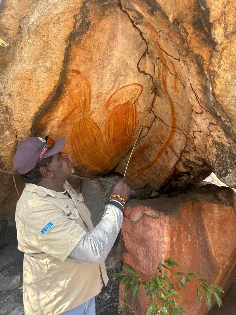
Staying here is a great way to support the local Indigenous community while experiencing the rich cultural and natural heritage of the Kimberley. The campground is managed by the Traditional Owners, who also offer guided tours to see the incredible Wanjina and Gwion Gwion (Bradshaw) rock art.
Hot Tip: Please note that pets are not allowed here. There is no internet or phone coverage up on the Ngauwudu (Mitchell Plateau). Bring your own firewood.
Ngauwudu (Mitchell Plateau)

I arrived early in the afternoon, set up camp, and headed straight to the Mitchell Falls Helicopter Transfer booking desk. I planned to hike in and fly back, but without booking ahead, my options were limited.
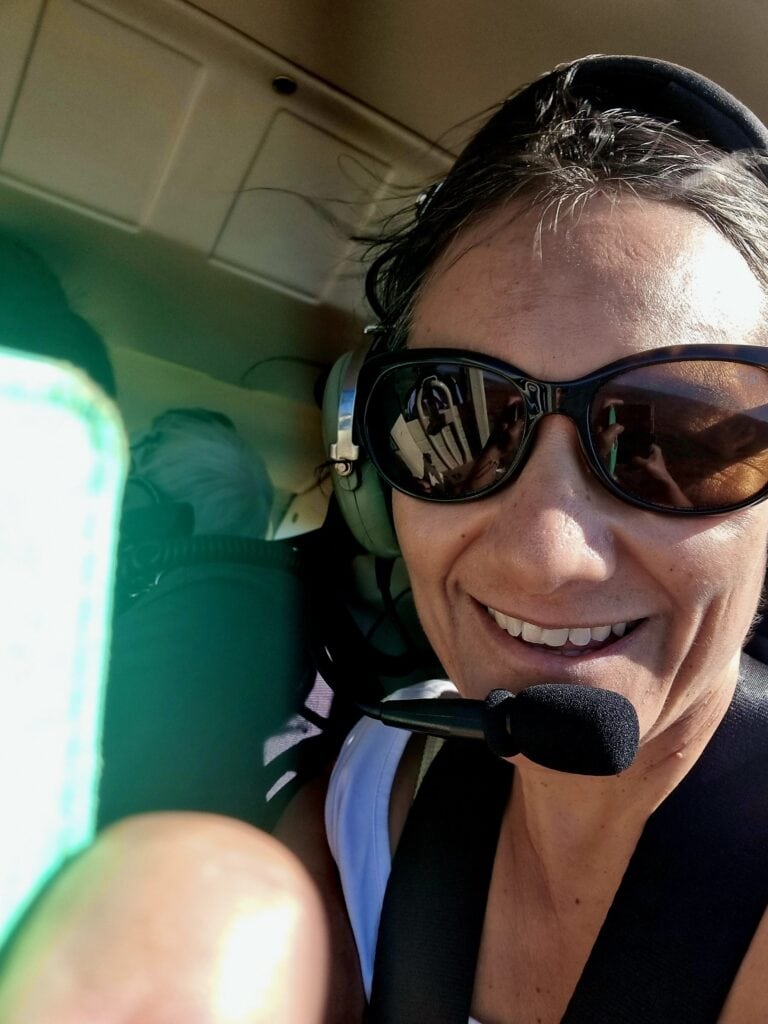
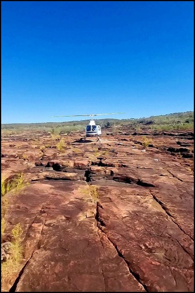
Travelling solo meant I needed to slot in where there was space — still, I was grateful to secure a flight for the next day.
I prefer not to book in advance. It keeps me free to stay longer in places that feel right or move on if I’m ready. That flexibility and spontaneity are worth the occasional challenge because I get to explore at my own pace.
The campground here has everything you need for comfort in the Kimberley: well-kept campsites and basic but reliable facilities. This place oozes that remote vibe that makes you want to slow down.

If you’ve got time on your first day, walk the short track to Bunjani (Little Mertens Falls). It’s a perfect spot for a swim and a great way to wash off the bulldust before your Mitchell Falls adventure.

Drysdale Station


Drysdale Station on the Gibb River Road is your gateway to hassle-free Punamii Uunpuu (Mitchell Falls) fun. There is also a rubbish dump across the road from the station. Leave your caravan behind and start early to do a day trip to soak in the falls’ breathtaking beauty. Some people I met while crossing the King Edward River were doing just that.
I wouldn’t recommend this option as it makes for a big, busy day. But if you’ve only got one spare day, it’s worth doing.
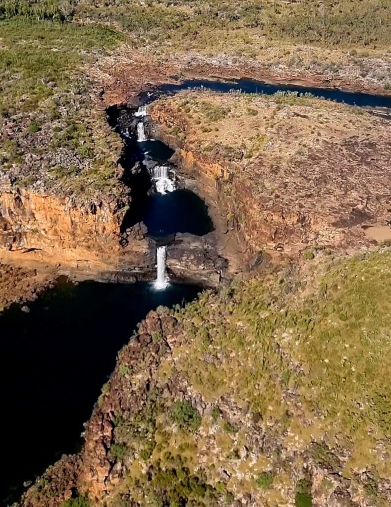
Drysdale Station can also organise scenic flights over the falls.
There are options, including plain flyovers or Trek Mitchell Falls (day Tour), which fly you up to the Plateau, 4WD transfer you to the track, and then you hike up to the Falls, have lunch, and then helicopter down.
The Hike
From the campground, it’s a 8.6 km return hike to Punamii Uunpuu (Mitchell Falls). The track is moderate to challenging — expect rocky sections, creek crossings, and little shade. The Mertens Creek crossing can be ankle- or knee-deep depending on the time of year.

I recommend allowing 3–4 hours return so you can take your time at the lookouts and stop at Little Mertens Falls or the pools above the main drop for a swim. If you’re not keen to walk both ways, you can take a one-way helicopter transfer — a great option if you want to combine the hike with a scenic flight.


Verdict
The Punamii Uunpuu (Mitchell Falls) road trip is no walk in the park. It’s a dusty, challenging adventure. This trip earns its place on my Ultimate Western Australia road trip. It’s about stepping into the unknown, tackling the hard bits, and coming out the other side with a story worth telling. The effort makes the reward sweeter, and every kilometre adds to the story. This is one for the bucket list.
Travel well.
Key Takeaways
- Mitchell Falls is a challenging yet rewarding destination on the Gibb River Road, demanding careful planning for access.
- Travellers must navigate rough 4WD routes or take scenic flights for stunning views of the falls.
- A Uunguu Visitor Pass is required to visit the area, respecting the indigenous culture and heritage.
- The hike to Mitchell Falls spans 8.6 km return, featuring rocky terrain and creek crossings, with options for helicopter transfers.
- Overall, visiting Mitchell Falls offers a mix of adventure and beauty, making it a bucket-list destination.